Halt the Moraine Sale -Toronto Star April 4 2003
Chapman Putman Map 1984Click Here
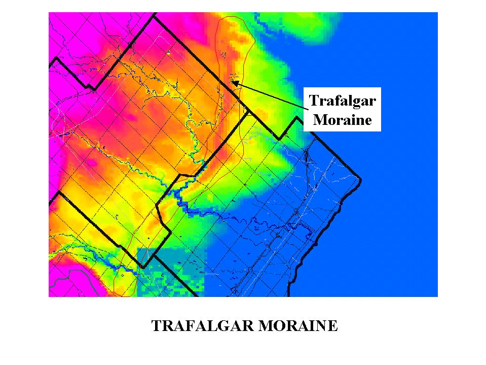
TRAFALGAR MORAINE
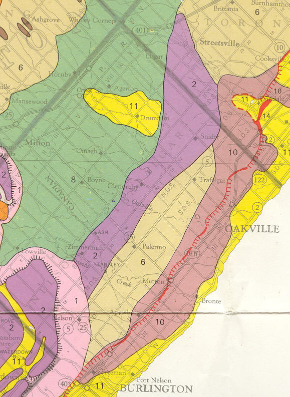
The Trafalgar Moraine is a subtle feature that stretches across the north parts of Oakville, extending eastward into Peel Region. The Moraine was formed as an end moraine, that is, it formed at the terminus of an ice sheet when the ice pushed materials into a ridge. The Trafalgar Moraine is composed of silty and clay rich Halton Till sediment. The Trafalgar Moraine cannot be compared to the Oak Ridges, Waterloo, Easthope or other interlobate moraines. These latter moraines form when ice sheets initially started melting and retreating. The ice would start to "unzipper", causing sediment laden meltwaters to flow off of the ice sheet and into the topographical lows where the ice has already melted. Over time these flowing meltwaters resulted in the accumulation of thick assemblages of sand and gravel that, when the ice finally melted, remain as topographically high piles of coarse grained materials. The moraines formed from different processes and are comoposed of very different types of materials.
Karrow (1987) notes that the moraine separates those areas to the north that were drowned in glacial Lake Peel, from those areas to the south that show no evidence of glacial lake sedimentation. As the ice finally retreated back into the Lake Ontario basin, there was a pause in the retreat (and likely a minor re-advancement) that pushed up the soils into the Trafalgar Moraine ridge. Glacial meltwaters were trapped in Lake Peel to the north resulting in the modification of the glacial landscape in this area. When the ice retreated from the vicinity of the Trafalgar Moraine, the waters in glacial Lake Peel escaped to the south. The thin deposition of clay and silt in glacial Lake Peel indicates that the moraine only paused for a short time before finally retreating into the Lake Ontario basin.
In the attached figure you can see that the Trafalgar Moraine is responsible for deflecting the east Branch 16 Mile Creek to the west where it meets the west branch. The combined rivers have eroded through the Trafalgar Moraine in the north part of Oakville.
Since the Trafalgar Moraine is comprised of silty clay soils the recharge to the groundwater system on the moraine is likely quite low, maybe on the order of 50 mm/yr. This would compare to recharge through coarser grained soils (e.g. Oak Ridges Moraine) where the recharge can be as high as 250 or 300 mm/yr. Having stated the low recharge rate, it must be noted that the moraine does provide groundwater discharge to many smaller streams that emerge from the toe of the moraine and flow through Oakville (e.g. 14 Mile Creek, McCraney Creek, Joshua Creek). In cases I believe that the discharge into these streams can occur year round (i.e. permanent flow). This discharge function is dependent on the small amount of recharge that does occur on the moraine. Therefore recharge must be fully understood at a subwatershed scale and it must be replicated if development were to occur on the moraine in order to maintain the discharge to the streams coming off of the moraine.
A further note of interest on the moraine is the hummocky nature of the topography as noted in the area between Trafalgar Road and 6th Line. This was only noted in August of 2001 when I had a chance to look at a close up air photo of a portion of the moraine. This type of topography is somewhat unique in Halton especially below the escarpment. This type of landform is significant from two points of view. Firstly owing to its uniqueness there could be an issue of landform permanence that might have to be addressed. With the development of the moraine this type landform would likely be eliminated. The hummocky topography itself is important in that it can significantly increase the recharge that is occurring on the moraine. In modelling that we did in the north parts of Halton the recharge had to be increased in areas of hummocky topography on the Paris Moraine. The hummocky topography essentially serves to hold water so that it is not drained off of the landscape. The hummocks are closed depressions that capture snowmelt and rainfall and store them on the land surface. Since the water does not runoff, it is allowed to sit in the hummocks and recharge the groundwater system. Thus despite the tight soils on the moraine, this type of topography can increase the recharge rate well above the number that is sighted above. In the case of the Paris Moraine we determined that the recharge rate had to be on the order of 250 to 300 mm/yr. The Grand River Conservation Authority has also noted similar conditions in other hummocky topography areas across their watershed.
The significance of the recharge to the overall groundwater system and to the streams that come off of the moraine still has to be examined. This can be looked at in a preliminary manner through an investigation of the nature of the streams that flow from the moraine, or through the installation of long term groundwater monitors.
I am trying to have one of the long term groundwater monitors currently being established by Conservation Halton placed up on the moraine, but so far we have not found a suitable well. We might install a new well through the Aquifer Management Plan.